
Destinations
Experiences
|
L A
D A T C O T O U R
S |
|
||||||||
| HOME | South America | Falkland Islands | Antarctica | Unique Destinations |
Unique Experiences |
Newsstand | ||||
 |
Lake Titicaca Map & Info |
ABOUT: |
 |
Nearby, on the Bolivian side of the lake,
arose the population and ceremonial center of Tiahuanaco, capital of one of the most
important civilizations of South America. Tiahuanaco ceremonial sites were built along the
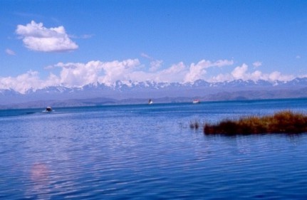
lake's shores, indicating that the lake was considered sacred at least 2,000 years ago. Excavations have uncovered the remains of five civilizations, one on top of the other, the last one ending a hundred years before the first Inca. Tiahuanaco was a pilgrimage site for the Incas. At the time of the Spanish Conquest, one of the most important religious sites of the Inca Empire was located on the Island of the Sun. Titicaca was perceived by its ancient cultures to be an inland sea connected to the ocean, mother of all waters. Today, people still believe that the lake is involved in bringing rain and that, closely associated with the mountain deities, it distributes water sent by them. The people who utilize the lake's resources still make offerings to her, to ensure sufficient totora reeds for boats, for successful fishing, for safe passage across its waters and for a mild climate. |
QUICK FACTS: (Gathered from a variety of places and not verified)
- About half the lake resides in Peru and half in Bolivia
- It is the highest navigable body of water at 3,821 (12,507 feet) meters
- It covers 8,300 square km, sunning 190 km NW to SE & is 80 km across
- It lies in a 60,000 square km basin between the coastal & eastern Andes
- The average depth is over 100 m with deepest point at 281 m
- 25 rivers, mostly from Peru, flow into the lake and a small outlet leaves the lake at Desaguadero on the Bolivia-Peru border, which is only 5% of the inflow with the rest lost in evaporation.
- The lake is the remnant of a vast area of water formed in the Ice Age known as Lake Bolivian
- The traditional totora-reed boats take 3 days to build and last 7-8 months while wooden boats take longer to build but last 7-8 years
- If someone falls into the lake, like a fisherman, it is traditional not to rescue them but to let them drown as an offering to the Earth Goddess Pachamama.