

Destinations
Experiences
|
L A
D A T C O T O U R
S |
|
||||||||
| HOME | South America | Falkland Islands | Antarctica | Unique Destinations |
Unique Experiences |
Newsstand | ||||
 |
PERUVIAN
RAINFOREST Tambopata Candamo
|
 |
ABOUT TAMBOPATA
CANDAMO RESERVED ZONE
Compliments of Rainforest Expeditions
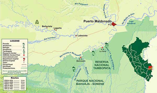 |
The Tambopata National
Reserve is a 275,000 hectare conservation unit created by the Peruvian
government in 1990 to protect the watersheds of the Tambopata and Candamo rivers (formerly
known as the Tambopata-Candamo Reserved Zone). It is adjacent to the huge 1 million
hectare Bahuaja Sonene National Park. Whilst the Tambopata National Reserve was created
with an underlying philosophy of sustainable resource use, the park was created with the
purpose of wholeheartedly protecting the forests within. Both conservation units protect
some of the last untouched lowland and premontane tropical humid forests in the Amazon.
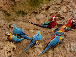
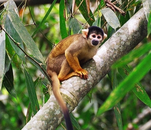
This Connecticut-sized area of pristine forest contains 600 bird species, 32 parrot
species (10% of the world’s total), 200 mammal species, 1200 butterfly species and
over 10,000 species of vascular plants. Less than 5000 people (equivalent to a minor league sports event) inhabit the Tambopata National Reserve’s “area of influence” to the north. They make a living of slash and burn agriculture, small scale gold mining, timber extraction, and hunting and fishing. One thousand Ese’ejas live in four titled communities within this area of influence. The undergoing pavement of the Interoceanic highway, joining Brazil’s north Atlantic coast with Peru’s Pacific Coast and access to the Asian markets presents the principal threat over the mid term to this region’s incomparable wilderness. Both the Tambopata National Reserve and the Bahuaja-Sonene National Park form part of the titanic 30 million hectare Vilcabamba-Amboro Conservation Corridor. The corridor is formed by 16 protected areas ranging from the Vilcabamba mountain range west of Cusco to the Amboro National Park in central Bolivia, and include Manu National Park, the Machu Picchu Historical Sanctuary and the Madidi National Park, among others. In addition, this corridor protects over 40 ethnic groups. Its objective is to spur the region’s development through participatory planning for the strengthening of local organizations, sustainable small businesses and agroforestry in order to minimize the loss of biodiversity. |
| Weather: | Rainfall: | Rainy Months | High | Low |
| 2000 mm a year (x .03937 = 78 +/- in) |
80% of the average rainfall occurs during November-March | 82 F to 93 F | 62 F to 73 F |